What You'll Find in This Article
Welcome to Email 4!
So far, you’ve learned about:
- Seongsan Ilchulbong (accessible volcanic crater)
- Butcher Shop BBQ (how locals eat)
- Dolphins & Coast (Jeju’s natural beauty)
Today: The mountain that made it all possible. And the breathtaking view that you earn when you climb it, even if you don’t reach the summit!
PART 1: Why You Shouldn’t Miss This
Pull up a map of Jeju. Notice anything unusual about the roads?
There’s no highway cutting through the middle. No direct route from north to south. Instead, roads loop around the perimeter in rings.
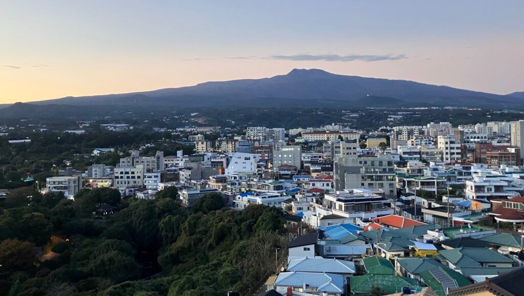
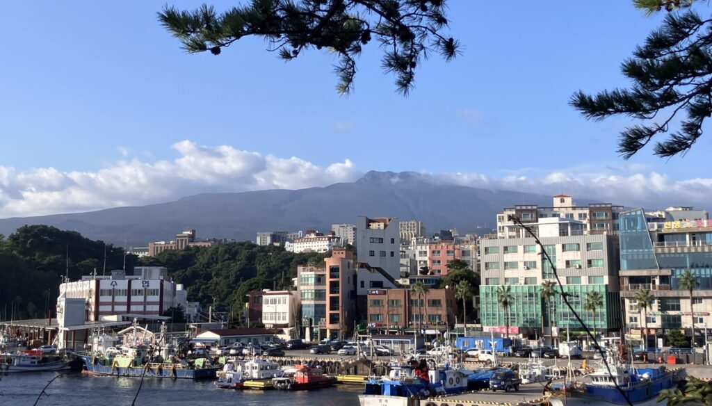
The reason? Hallasan (한라산) sits in the middle, dominating everything.
At 1,947 meters, Hallasan is South Korea’s tallest mountain. But more importantly: this mountain IS Jeju. Without Hallasan, there is no Jeju.
This shield volcano erupted repeatedly over millions of years, building up layer upon layer of volcanic rock until it broke the ocean surface and became an island. Almost every beach, every village, every field exists because Hallasan erupted.
Hallasan shapes everything about your trip:
Getting around: You can’t drive straight across the island. What looks close on a map takes 1.5 hours because you’re driving around a mountain.
Weather: It creates microclimates. Jeju City sunny doesn’t mean Seogwipo sunny.
Culture: The mountain influenced everything from agriculture to architecture to social structure.
Most visitors never climb Hallasan. And that’s okay.
It requires 8-9 hours for summit trails, strict cutoff times, advance registration, and genuine physical fitness. Not everyone can do it. Not everyone wants to.
There are easier non-summit trails around Hallasan that are family-friendly and still provide amazing views.
But if you CAN make the summit, you absolutely should.
My Experience
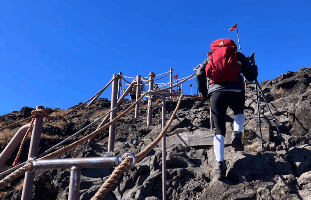
I climbed Hallasan in November (my third trip to Jeju). It took 4 hours ascending Seongpanak Trail and an agonizing 5.5 hours descending Gwaneumsa Trail because my right knee gave out on the wet, jagged rocks. I was humbled, exhausted, and in pain.
And I’d do it again. In fact, I will.
Because standing at the summit, looking out at the coastline, you realize: everything down there—every village, every oreum, every stone wall—is linked to right where you’re standing.
You understand Jeju in a way that’s impossible without climbing the mountain.
BTW: If you’re thinking “I’m not a hiker,” I wasn’t either. I used to get winded climbing 10 flights of stairs. But I trained, prepared, and made it. You can too.
The Two Options: Summit vs. Partial Trails
Summit Trails (8-9 hours, strenuous, advance registration required)
Seongpanak Trail (성판악)
- Distance: 9.6km one way (19.2km round trip)
- Time: Approximately 4.5 hours up, 3 hours down
- Difficulty: Moderate – gentler gradient, well-maintained
- Experience: Forest trail most of the way, then opens up to stunning coastal views
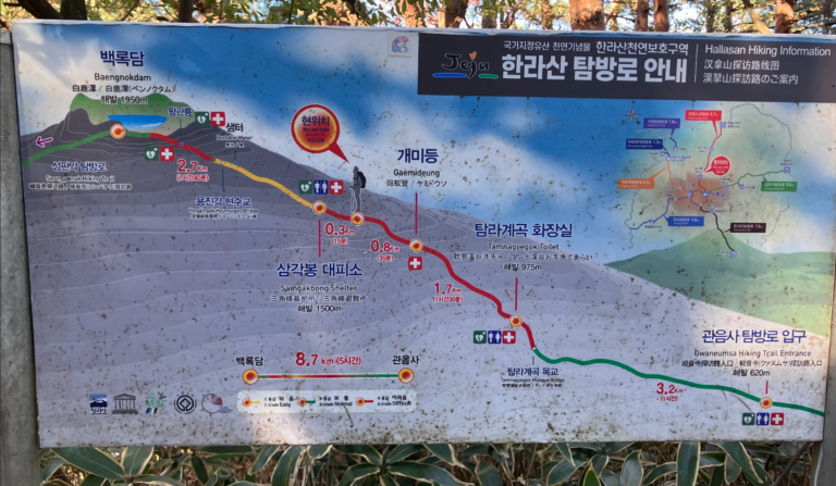
Gwaneumsa Trail (관음사)
- Distance: 8.7km one way (17.4km round trip)
- Time: Approximately 5 hours up, 3.5 hours down
- Difficulty: Challenging – steeper, rockier, slippery when wet
- Experience: 1.8km stretch of knee-high jagged volcanic rock, cave entrance, suspension bridges, north side summit views
Strategy: Most people go up and down the same trail (easier logistics). Advanced hikers go up one, down the other.
My mistake: I went up Seongpanak (easier) and down Gwaneumsa (harder). The descent destroyed my right knee. When I do it again: up Gwaneumsa, down Seongpanak. Suffer the climb, not the descent.
Partial Trails (2-4 hours, moderate, no registration needed)
Eorimok Trail (어리목)
- Distance: 4.7km one way
- Time: 2-2.5 hours round trip
- Difficulty: Easy-moderate, perfect for families
Yeongsil Trail (영실)
- Distance: 3.7km one way
- Time: 1.5-2 hours round trip
- Difficulty: Easy, shortest option, mostly stairs
What you get: Beautiful forest walks, decent elevation, mountain experience.
What you don’t get: Summit crater, 360° coastal views, the full “I climbed South Korea’s tallest mountain” experience.
PART 2: How to Make it Happen
Registration Requirements (Summit Trails Only)
You must register online before hiking.
Website: https://visithalla.jeju.go.kr
How it works:
- Limited daily hikers allowed per trail
- Register for your starting trail (can descend via different trail)
- Receive QR code via email/text
- Must scan QR at trailhead entrance and checkpoints
- Screenshot your QR code (cell signal not guaranteed in forests)
No registration means no hiking. Rangers will turn you back.
Start Times & Cutoff Times (Strictly Enforced)
Start window: Typically 5:00 AM – 8:00 AM (varies by season – check website)
Checkpoint cutoffs: Usually 11:30 AM (varies by season)
Summit cutoff: Usually 1:30 PM (varies by season)
Rangers enforce these with zero flexibility. 5 minutes late means turned back. No exceptions. No appeals.
Strategy: Start as early as possible. Create a buffer against weather delays, pace issues, or unexpected problems.
When to Climb
Fall (September-November): Best season. Clear weather, autumn colors, crisp air. I climbed in November—perfect conditions.
Spring (March-May): Second best. Wildflowers, pleasant temps, good visibility.
Summer (June-August): Brutally hot and humid near summit (no shade for final 2 hours). Bring lots of water. Possible afternoon thunderstorms.
Winter (December-February): Beautiful with snow, but requires crampons and winter climbing gear. Not recommended unless experienced.
Weather reality: Check forecast, but don’t trust it completely. Jeju weather changes fast. The summit can be clear while the base is cloudy, or vice versa. Always pack layers.
Getting There
By bus (cheapest, requires planning):
- Check KakaoMap and NaverMap
- Seongpanak: Bus 281 from Jeju City (approximately 45 minutes, every 30-40 minutes)
- Gwaneumsa: Bus 475 from Jeju City (approximately 40 minutes, once per hour – check schedule)
First bus timing: Check exact schedules night before. First buses usually run 5:30-6:00 AM to get hikers to trailheads just after start time.
Return buses: Last buses serving Gwaneumsa usually end around 7 PM. If you’re delayed on trail, you could miss them. Have backup plan (taxi number or Uber app ready).
By taxi: Approximately ₩30,000-40,000 from Jeju City. Reliable, faster, no schedule stress. Worth it for early morning, especially if you are in a group.
By rental car: Parking lots fill up by 6:00 AM (seriously). Arrive before 5:30 AM or accept overflow parking 10-15 minute walk away.
If going up one trail, down the other: Park near Jeju National University, bus to/from both trailheads. Or arrange taxi pickup.
What to Bring (Non-Negotiable)
Water: Minimum 2-3 liters. More in summer. Some water stations exist but don’t count on them.
Food: Lunch plus snacks. Nothing available on trails. Bring calorie-dense foods (nuts, energy bars, chocolate, kimbap).
Footwear: Proper hiking boots with ankle support. Not sneakers. Not running shoes. Trails are rocky, uneven, slippery when wet.
Hiking poles: Strongly recommended. Distribute impact to arms, save your knees on descent, help with balance on rocky sections.
Layers: Summit 10-15°C colder than base. Even in summer, bring warm layer. Pack:
- Base layer (moisture-wicking)
- Mid layer (fleece or light jacket)
- Wind/rain shell
- Hat and gloves (fall/winter/spring)
Other essentials:
- Headlamp (if starting before sunrise)
- Sunscreen
- First aid kit (blister treatment, pain reliever)
- Trash bag (pack out everything)
- Phone fully charged
- Emergency contact info
On The Trail: What to Expect
Seongpanak:
- First 7km through forest (can feel monotonous)
- Gradual, steady climb
- Final 2.6km opens up – vegetation falls away, views emerge
- Can see east and south coasts (if clouds cooperate)
- Well-maintained wooden stairs and paths
Gwaneumsa:
- Moderate incline at the start
- Gets even more steep in the middle over rocky, jagged terrain over 1.8km (knee-high rocks)
- Tough ascending, tougher descending, especially if rocks are wet
- You’ll see a cave entrance, and cross suspension bridges
- Views of north coast and Jeju City
- More dramatic but more challenging
At the summit:
- Baengnokdam crater (walk around rim)
- 360° views (on clear days)
- Windy – bring windbreaker
- No shelter. Plan accordingly.
- Photos, rest, marvel at what you just did
Descent:
- Takes longer than you think
- Knees bear the impact
- Use poles, go slow, zigzag on steep sections
- Take breaks – no need to rush
Training & Preparation
If you’re not a regular hiker, start 4-6 weeks before:
- Stair climbing (build up to 30-60 minutes)
- Walking with weighted backpack
- Eccentric leg exercises (slow squats, lunges, wall sits)
- Build endurance gradually
Week before:
- Reduce intensity, let body rest
- Stay hydrated
- Get good sleep
- Check weather forecast daily
Don’t underestimate this hike. The distance, elevation gain, rocky terrain, and time pressure combine to make it challenging. But it’s absolutely doable with preparation.
PART 3: Korean You’ll Actually Use
At the Trailhead
I’m registered: “등록했어요” Romanization: Deung-rok-hae-sseo-yo When: Showing rangers you’re registered (though QR scan usually suffices)
On the Trail (Fellow Hikers)
Hello: “안녕하세요!” Romanization: An-nyeong-ha-se-yo When: Passing other hikers (greetings aren’t common in Korea in general, but trails seem to be an exception)
You can do it! / Fighting!: “화이팅!” Romanization: Hwa-i-ting! When: To struggling hikers or when someone encourages you Response: “감사합니다!” (Kam-sa-ham-ni-da) = Thank you!
Where’s the bathroom: “화장실 어디예요?” Romanization: Hwa-jang-shil eo-di-ye-yo? When: At rest stations/shelters
Is there water: “물 있어요?” Romanization: Mul i-sseo-yo?
Please help me: “도와주세요!” Romanization: Do-wa-ju-se-yo!
I’m hurt: “다쳤어요” Romanization: Da-chyeo-sseo-yo
Celebrating at Summit
We did it: “해냈어요!” Romanization: Hae-nae-sseo-yo!
Please take a photo: “사진 찍어주세요” Romanization: Sa-jin jji-geo-ju-se-yo
Why Hallasan Matters
Remember Email 1 when I said Seongsan gives you the volcanic experience without requiring summit fitness? That’s still true.
But Hallasan offers something Seongsan can’t: understanding.
When you stand at 1,947 meters, looking down at the island you’ve been exploring—Seongsan to the east, Seogwipo to the south, Jeju City to the north, the oreums scattered everywhere—you finally get it.
This mountain created most of it.
The basalt columns at the coast? Lava flows from Hallasan. The lava tubes you explored? Hallasan’s eruptions. The 360+ volcanic cones? Baby Hallasans. The stone walls dividing every field? Rocks that erupted from right where you’re standing.
Everything you’ve been experiencing makes sense now. You’re not just visiting an island. You’re walking around a giant volcano.
That’s worth sore knees and 9 hours of hiking.
What If You Can’t/Won’t Climb?
Most Jeju visitors never climb Hallasan. And they still have amazing trips.
If you have limited time (2-3 days), have physical limitations, aren’t interested in strenuous hiking, or just don’t want to—you can still experience Hallasan:
- Do a partial trail (Eorimok or Yeongsil) – 2 hours, beautiful, no summit pressure
- Drive partway up mountain roads for views
- Visit Jeju Stone Park (showcases volcanic rock formations)
- Simply observe how the mountain shapes everything around you
Hallasan will affect your trip whether you climb it or not. It affects weather, routes, culture, landscape, everything. But climbing to the summit is optional.
What’s Next?
In two days, Email 5: The Haenyeo. These are the women who free-dive 20 meters underwater without breathing equipment, holding their breath for 2 minutes, harvesting seafood. They’re disappearing—within 20 years, this tradition may only exist in museums.
We’ll discuss how to see them while we still can.
But first: decide if you’re climbing Hallasan. And plan ahead!
— Ed
