What You'll Find in This Article
Jeju is famed for walks that deliver stunning views, interesting landscapes, and actual enjoyment without requiring technical hiking skills, expensive gear, or masochistic determination.
Yup, you don’t need trail boots, walking poles, or protein bars to explore Jeju on foot. You just need comfortable shoes and a willingness to stop at a cafe halfway!
What Makes a Walk Great Even for Hike-Haters
After years of exploring Jeju on foot, here are my criteria that define walks that regular humans genuinely enjoy:
About an hour, give or take: Not 20 minutes (too short to feel like you did anything). Not three hours (that’s actual hiking). Roughly 60-90 minutes of pleasant movement.
Mild elevation or easy places to rest: If you’re gasping for breath, something went wrong. Gentle slopes are fine. Short uphill sections are fine. Continuous steep climbing is not.
Something worth looking at along the way, not just at the end: The view from the top is nice. But what about the 45 minutes it takes to get there? If the journey is boring, it’s not hike-hater friendly.
A cafe, restaurant, or snack stop somewhere in the equation: Before, during, or after. Ideally during. Food and a warm drink makes everything better.
Looking for the details on the Mini Jeju Olleh Trail?
If you are here for the mini Olleh Trails that I designed for my family, the details have been moved to the main Olleh Trail Guide here.

URBAN WALKS: CHERRY BLOSSOMS, MURALS, AND ART STREETS
Jeonnongro Cherry Blossom Street & Mural Neighborhood
Location: Jeju City, near Dongmun Market (동문시장)
Time needed: 1-2 hours
When: Year-round for murals; late March through mid-April for cherry blossoms
In spring, the king cherry trees create tunnels of pink-white blossoms arcing over multiple city blocks. Walk underneath while petals fall like snow.
But even without cherry blossoms, this neighborhood rewards exploration. Over 100 murals cover entire walls depicting Jeju culture and nature. Haenyeo diving. Hallasan rising. Native animals. The paint captures the island better than most museums.
The murals are everywhere. Turn down any side street and you’ll find them covering building facades, alley walls, even garage doors. Some blocks feel like outdoor art galleries.
Coffee break: Several cafes in the neighborhood, and Mega Coffee for the budget-conscious. Korean chain coffee for ₩1,500-2,500 per drink. Tastes fine. Saves money.
Lee Jung Seop Street
Location: Seogwipo City, connecting downtown to the waterfront
Time needed: 45-90 minutes depending on how far you extend
When: Year-round
This is Seogwipo’s most interesting urban walk. Art installations line the street commemorating Lee Jung Seop, one of Korea’s most famous painters. His former home sits along the route at the bottom of the hill, now preserved as part of a small art museum. Entrance to his former home is free, entrance to the museum is paid, though.
The street starts at Seogwipo Maeil Olle Market (매일올레시장), Seogwipo’s traditional market where locals used to shop for produce, seafood, and prepared foods, but it has since been taken over by tourists.
Pro tip: The street slopes downward from the market to the waterfront. Start at Seogwipo Maeil Olle Market and walk down to Lee Jung Seop Art Museum. Gravity helps. Walking uphill from the waterfront is steeper and less pleasant.
Bonus extension: If you are still looking to walk further, keep going another 30-45 minutes to Saeyeongyo Bridge (see next item), and then stroll over to Saeseom Island for an additional 60 minute loop of pleasant coastal scenery with great views of the port.
Saeyeongyo Bridge & Saeseom Island
Location: Seogwipo waterfront
Time needed: 1 hour for the loop
When: Year-round; evening for light and water display
The sail-shaped bridge inspired by traditional Jeju teu boats (테우) connects the mainland to tiny Saeseom Island. Cross the bridge, walk a pine forest loop with harbor views, then return.
The island offers views of Munseom Island (문섬) and the Seogwipo harbor. In the evening, the bridge lights up and water displays activate.
Wind can be strong. If the winds are gusting, expect to lean into the breeze while crossing.
HILLS WITH VIEWS: OREUMS WITHOUT THE COMMITMENT
Sarabong Oreum
Location: Jeju City, near the harbor
Time needed: 30-45 minutes round trip
When: Year-round; spring for cherry blossoms; sunset for harbor views
This is where Jeju City locals living in the old city go for exercise and sunset views. A 15-minute climb brings you to the top (143 meters elevation) with panoramic views of the harbor, downtown Jeju City, and the northern coast.
In spring, cherry blossoms bloom along the paths. In any season, you may see locals enjoying the view or doing their daily exercise routine at the top.
Wild rabbits sometimes hop around the trails. They’re used to people and mostly ignore you.
Dodubong Oreum & Rainbow Coastal Road
Location: Next to Jeju International Airport
Time needed: 1-2 hours depending on how far you walk
When: Year-round
Dodubong sits at 65 meters elevation right next to the airport. The 10-15 minute steep climb gives you views of Jeju City, Hallasan, and planes landing and taking off. If you want a gentler effort, a 20-30 minute trail wraps around the Oreum, letting you trade steepness for distance walked.
K-drama fans recognize it from Welcome to Samdal-ri. The high school dating scene where they watch flights? Filmed here.
But the real advantage is flexibility. Walk the Rainbow Coastal Road from Dodubong toward downtown Jeju City, stopping at cafes and restaurants along the way.
If you get tired, buses run periodically back to your starting point. So, what I do is, if I am walking the Rainbow Coastal Road with people who don’t love walking, I check the bus schedules first. Then, I park near (or take a taxi to) a spot where we will have plenty of time to catch the infrequent bus. We take it as far as I think my non-hiker companion can handle, then we take our time to walk back, pacing ourselves.
The concrete trail has Rainbow colored blocks on the side that are pretty to look at and Insta-famous. It hugs the lava rock coastline, and is an urban coastal walk, not wilderness hiking. Cafes every few blocks. Restaurants. Convenience stores. Minimal pain.
Part of: Jeju Olleh Trail Route 17, but you can walk as much or as little as you want
BEACH WALKS: LOW TIDE SURPRISES
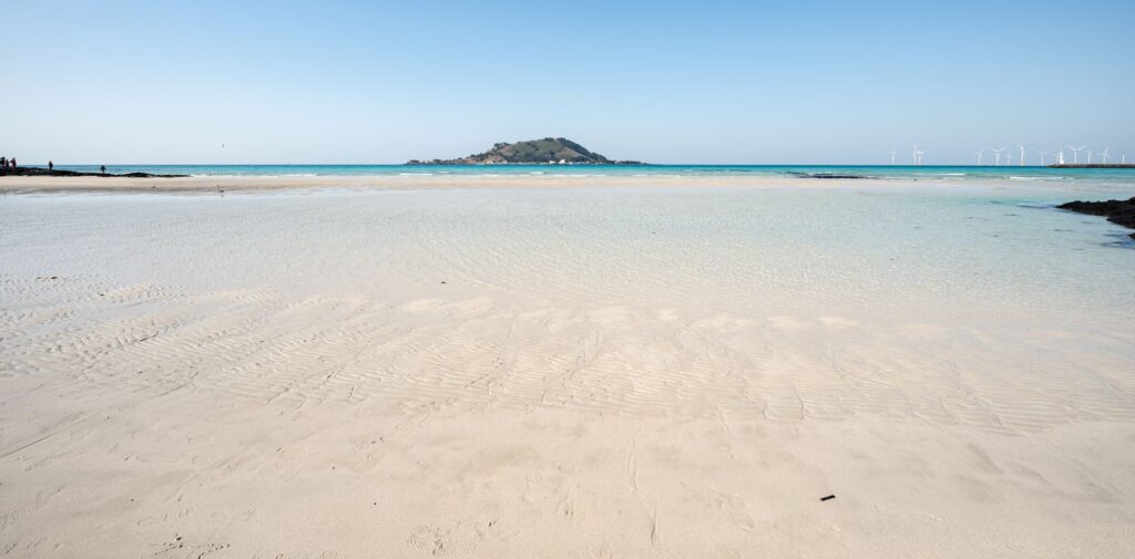
Pyoseon Beach at Low Tide
Location: Eastern coast, near Seongsan
Time needed: 45-60 mins
When: Check tide schedules; for walkers, best at low tide
At low tide, Pyoseon reveals a wide, flat expanse of golden sand stretching far into the ocean. Walk barefoot on firm packed sand. The beach extends much farther than you’d expect.
This isn’t dramatic scenery. It’s peaceful, meditative walking on a golden plain that appears when the ocean pulls back.
Timing: This is nature, so tide schedules change daily! Check tide websites or apps before going. Mid to low tide is ideal.
Gwangchigi Beach
Location: Eastern coast, north of Seongsan Ilchulbong
Time needed: 45-90 minutes
When: Low tide preferred
Black and white sand mix on this beach. At low tide, flat rocks emerge from the water creating natural (but slippery) walkways. Across the water, Seongsan Ilchulbong (the volcanic crater) rises dramatically.
A 4.3 Massacre memorial sits at the beach entrance. This beach holds heavy history beneath its beautiful surface. For the full story, see the dark tourism article.

COASTAL HEADLAND LOOPS: DRAMA WITHOUT THE ELEVATION
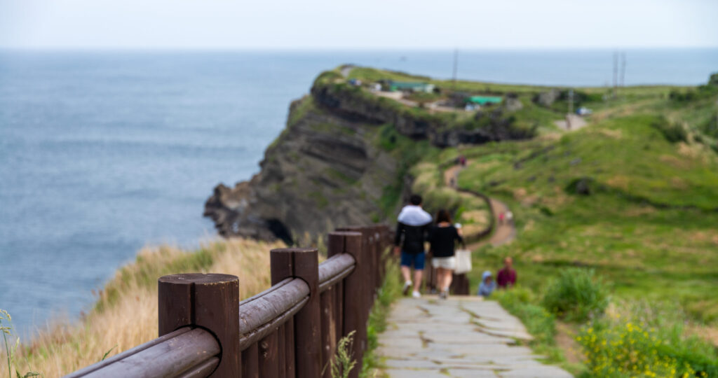
Seopjikoji
Location: Eastern coast, near Seongsan
Time needed: 1-1.5 hours
When: Year-round
Seopjikoji offers the same dramatic coastal scenery as Seongsan Ilchulbong (the famous sunrise peak) without the stairs or crowds. Walk a coastal headland loop past volcanic cliffs, yellow canola flowers, and sweeping views of Jeju’s east coast.
This is easier than climbing Seongsan. Same visual drama. No elevation suffering.
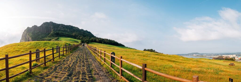
Songaksan Loop
Location: Southwestern coast, near Moseulpo
Time needed: 1-1.5 hours
When: Year-round; sunset recommended
Songaksan (송악산) is a tuff cone rising 104 meters above the southwestern coast. The loop trail circles the crater rim with ocean views in every direction. On clear days, you can see Marado Island (Korea’s southernmost point) and Gapado Island offshore.
The Japanese military built underground tunnels here during World War II to house suicide torpedo boats. You might still be able to see the entrance of a few.
The elevation gain is moderate. The views are exceptional.
WALKING WITH WINDMILLS
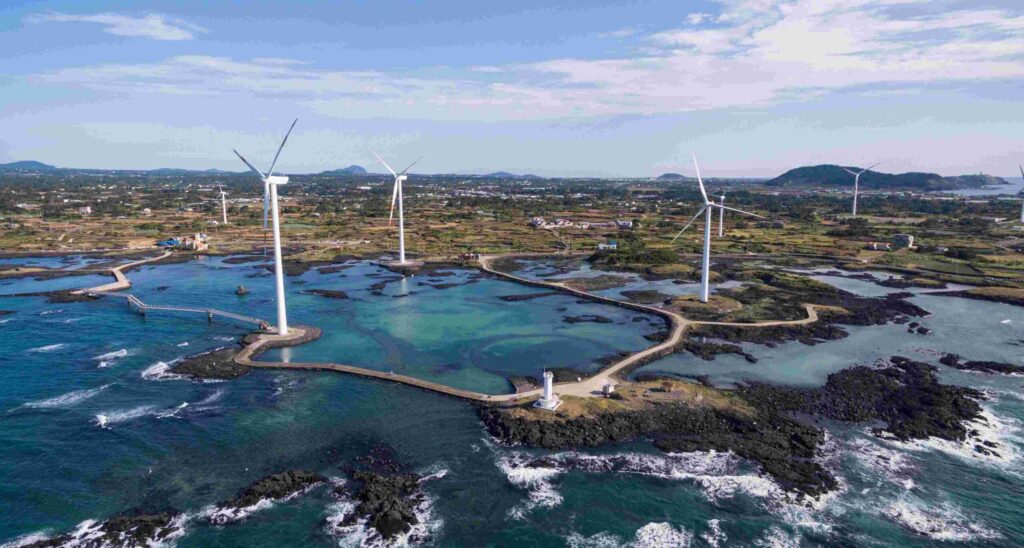
Sinchang Windmill Coastal Road
Location: Western coast, north of Hangyeong
Time needed: 1-1.5 hours
When: Year-round; sunset strongly recommended
Walk the west coast loop with offshore wind turbines spinning in the distance. Raised pedestrian walkways protect you from waves during high tide. A haenyeo diver statue stands in shallow water near the start. The Sinchang Lighthouse marks the apex.
Sunset here delivers. The wind turbines silhouette against orange and pink skies. The ocean stretches endlessly west.
Wind is real. Dress accordingly. Windbreakers or light jackets even in summer. In winter, bundle up.
Haengwon Town to Gimnyeong Beach
Location: Northeast coast
Time needed: 1-1.5 hours
When: Year-round
Walk the northeast coast from Haengwon Town toward Gimnyeong beach with lava rock, pretty beaches, and windmills lining the route. The Gimnyeong-Woljeong windmill coastal road stretches behind you. Cafes cluster around Woljeongri.
Cafe scene: Abebebe Bakery Bikilla and the adjoining Camel Coffee mark the start of this hike. Expect ocean views, good coffee, and crowds on weekends.
Getting there: Map to Camel Coffee in Haengwo-ri.
WALKS WITH STORIES: HISTORY BENEATH YOUR FEET
Sumbisori-gil: Haenyeo Museum to Byeolbanjin Walled Town
Location: Northeastern coast
Time needed: 60-180 mins, depending on whether you decide to take a bus to halve the distance.
When: Year-round
This trail connects the Haenyeo Museum to Hado village through farmland, coastline, and past defunct haenyeo rest shelters (불턱, bulteok) made out of lava rock. Walk the same paths haenyeo have used for generations to reach their diving grounds.
The trail isn’t dramatic. It’s quietly meaningful. Farmland transitions to coast. Stone walls line the path. You pass bulteok where haenyeo used to warm themselves between dives. The ocean appears and disappears as the trail meanders.
This walk deepens if you’ve already learned about haenyeo. If you visited the museum or learned about the sea women tradition, walking Sumbisori-gil connects the story to the landscape.
Part of: Not officially part of Olleh Trail, but uses some overlapping paths
Altteureu Airfield
Location: Southern coast, mid-point of Olleh Trail 10
Time needed: 30-60 minutes
When: Year-round
The name means “vast plain below” in Jeju language. Ordinary. Even poetic.
The Japanese military built this massive airfield during their occupation of Korea, using it to launch air attacks on Nanjing during the invasion of China. After World War II ended, it became a staging area for military operations during the 4.3 Massacre, serving as a base from which scorched-earth operations were launched into mid-mountain villages.
Today it’s a quiet, windswept field, which much of it turned back into farmlands. The Jeju Olleh Trail 10 passes directly through. Japanese anti-aircraft gun positions remain scattered across the area. The Seodal Oreum Memorial commemorating thousands murdered during the 4.3 massacre sits just minutes away.
Most hikers walk through without knowing the history. The airfield itself is flat and easy walking. No elevation gain. Just open space and wind.
This is a place where the landscape holds more than it shows.
Note: For the full story of Jeju 4.3 Massacre sites, see the dark tourism article. This walk can be emotionally heavy, but you do not have to know the backstory to appreciate the serenity.
Part of: Jeju Olleh Trail Route 10

TEA PLANTATION WALKS
Osulloc Tea Museum & Seogwang Tea Garden
Location: Western Jeju, near Seogwipo
Time needed: 1-2 hours
When: Year-round
Even though I dislike going to Osulloc (I hate crowds), I have to be honest and include it here because its Seogwang Tea Garden surrounding it is Korea’s largest organic tea farm. Two walking areas exist: a small field beside the Innisfree store and a larger field across the main road from the cafe and gift shop, which is what the “museum” really is.
The fields farther from the cafe see fewer crowds – except when tour buses pull in and disgorge their hordes. However, if you just keep walking between the rows of green tea bushes striping the hills, you’ll eventually find solitude.
The displays that are supposed to be part of the museum take less than 5 minutes to see, so don’t worry about budgeting too much time here. Since this is part of the cafe and gift shop, it’s free to enter and open year-round. An observatory on upper floors overlooks the tea fields.
Cafe warning: The museum cafe serves matcha ice cream and tangerine tea but expect crowds and tourist prices.
This is a flat, easy walk through cultivated fields. No hiking skills required. The museum and Innisfree House add built-in break points.
WATERFALL WALKS: PAVED PATHS TO NATURAL BEAUTY
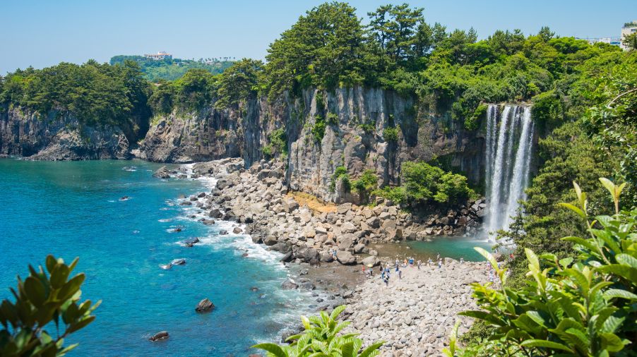
Jeongbang Waterfall
Location: Seogwipo City waterfront
Time needed: 30-45 minutes
When: Year-round
Jeongbang is Jeju’s only waterfall that falls directly into the sea. The 23-meter cascade drops straight into the ocean below.
Paved, flat paths lead to viewpoints. Minimal elevation. Maximum payoff. This is more of a short walk to a viewpoint than a hike, but it qualifies for hike-haters who want something impressive without effort.
I would only come here if I am already in Seogwipo City and looking to do a hike in good weather. You come for the hike, not the waterfall per se. Don’t get me wrong, it’s pretty, but it’s no Iguazu, Victoria, or Niagara.
PRACTICAL INFORMATION
What Makes These Work
These walks share key features that make them genuinely enjoyable for non-hikers:
Escape routes: Get tired? Buses run regularly in most places. Need a break? Cafes line most routes. Want to bail? You’re never far from civilization and a taxi is just an Uber away.
Built-in rest stops: Urban walks have cafes every few blocks. Coastal walks have benches with ocean views.
Interesting the whole way: These walks offer something worth looking at continuously. Cherry blossoms overhead. Ocean views beside you. Windmills in the distance. Tea fields stretching away.
Timing Tips
Cherry blossoms: Late March to mid-April
Beach walks: Best at low tide (check tide schedules daily)
Sunset walks: Try to catch Golden Time, typically 30-60 minutes before any given day’s sunset.
Tea plantations: Year-round, but spring and fall offer most comfortable temperatures
Check weather: Jeju’s weather changes quickly. Bring a light jacket even on sunny days.
What to Bring
Comfortable shoes: Not hiking boots. Just comfortable walking shoes or sneakers.
Water: Bring some but don’t overpack. You’ll pass convenience stores and cafes.
Light jacket: Even on warm days, coastal wind can be cool.
Cash: Cards are accepted almost every where, but just in case some small cafes and vendors prefer cash.
Transportation
Urban walks (Jeonnongro, Lee Jung Seop Street, Sarabong): Walk or short bus ride from city centers.
Coastal walks (Sinchang Windmill Road, Seopjikoji): Bus accessible but car gives more flexibility.
Tea plantations (Osulloc): Bus accessible from Jeju City.
Remote areas: Some walks work better with a car or taxi.
Download Kakao Maps or Naver Maps for bus routes and schedules. Watch out for infrequent local buses. Last buses from remote areas leave around 8-9 PM. Check out our article on getting around Jeju by bus.
ONE MORE THING
Beautiful scenery doesn’t require suffering. Cultural immersion doesn’t demand technical skills. Memorable experiences can happen on flat ground.
These walks deliver everything that makes Jeju special—volcanic landscapes, ocean views, cultural sites, local atmosphere—without requiring you to pretend you’re training for Everest.
Plan for your own hikes (even if you hate hiking) with the Jeju Trip Planner, and you’ll actually remember these walks fondly instead of blocking them out like traumatic memories.
