What You'll Find in This Article
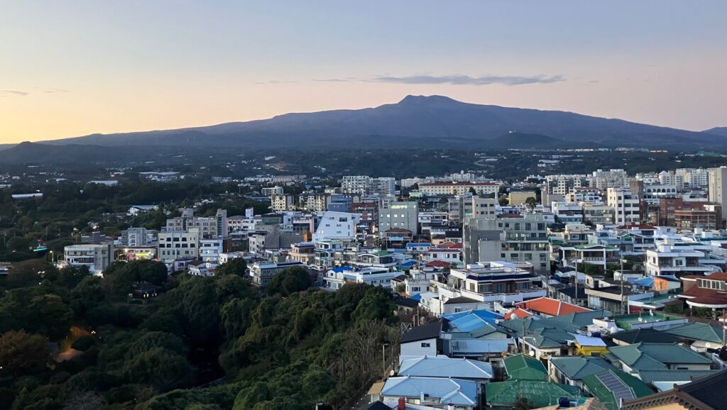
From the very first time I visited Jeju, I’ve felt this magnetic draw toward the mountain that sits in its middle—Hallasan (한라산).
Its majesty and beauty, yes. Its dominance? Of course.
But what really struck me was that it felt like it was beckoning me to climb it.
It would be another year, on my third trip to Jeju, before I would make the trip (I got distracted by the Jeju Olleh Trail!).
But in the meantime, I learned plenty about the mountain.
And what I learned proved to be useful not just for my climb, but also for planning my time on the island.
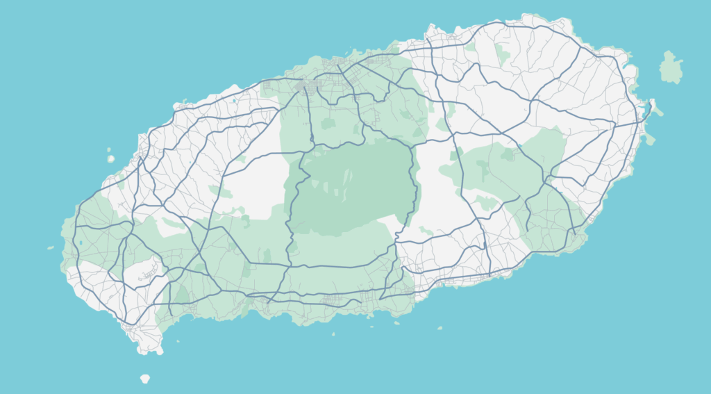
Pull up a map of Jeju Island. Notice anything unusual about the roads?
There’s no road cutting straight through the middle. No direct route from north to south or east to west through the center. Instead, most of the roads loop around in rings.
The reason? Hallasan (한라산) sits right in the middle, dominating the island both literally and figuratively.
Understanding Hallasan is key to understanding Jeju itself. This isn’t just a pretty peak to photograph—it’s the reason the island exists.
Meet The Mountain
At 1,947 meters, Hallasan is South Korea’s tallest mountain.
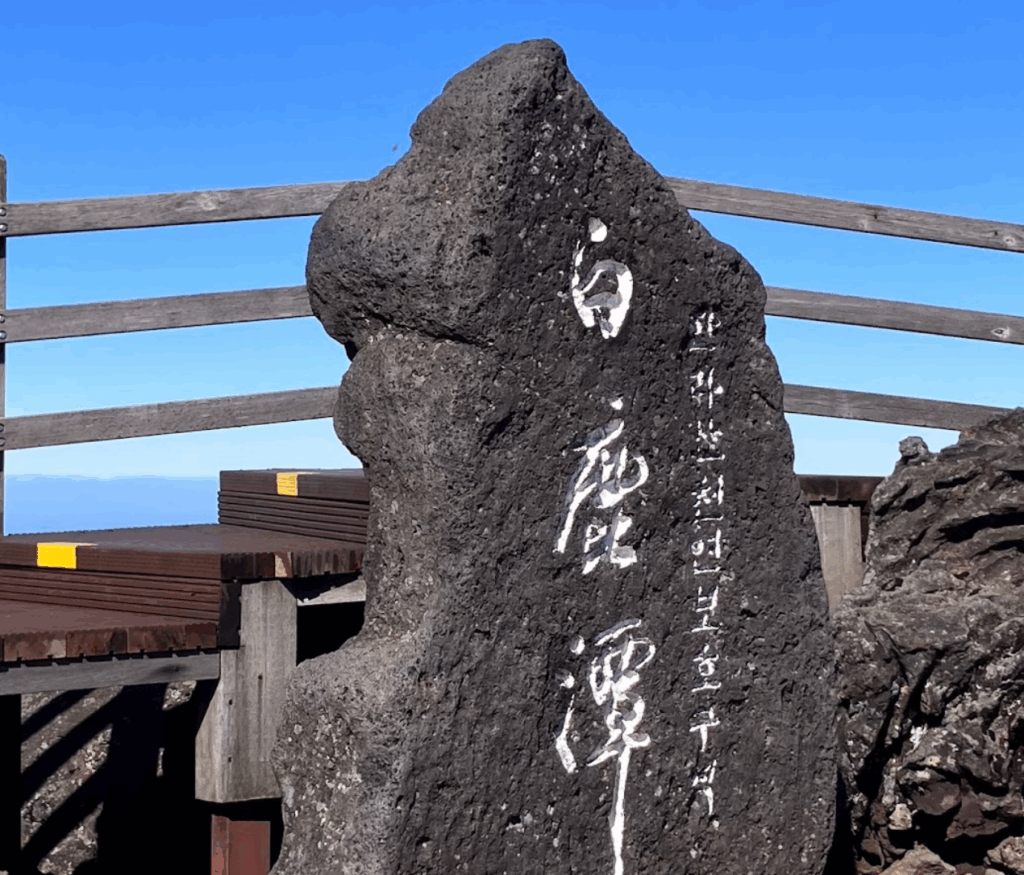
At the summit sits Baengnokdam (백록담)—White Deer Lake. The crater is approximately 400 meters across. Whether you see water in it depends entirely on recent rainfall, not the season. After a dry spell, it can be completely empty.
Hallasan isn’t dramatically tall compared to other famous peaks like Japan’s Mount Fuji (3,776 m), Malaysia’s Mount Kinabalu (4,095 m), or Africa’s Mount Kilimanjaro (5,895 m).
But what it lacks in dramatic height, this shield volcano makes up for in significance.
This mountain was one of the main creators of Jeju Island. Just about everything else—every beach, every village, every field—exists because Hallasan erupted repeatedly over millions of years, building up layer upon layer of volcanic rock until it broke the ocean surface and became an island.
Without Hallasan, there is no Jeju as we know it today.
Every stone on this island came from this mountain.
The black volcanic rock that forms those distinctive stone walls you see everywhere? Hallasan.
The lava tubes that honeycomb the landscape? Hallasan.
The porous soil that drains water too quickly for rice cultivation? Hallasan.
All Hallasan.
How Hallasan Affects Your Trip Planning
Getting Around Jeju Means Getting Around Hallasan
When a mountain sits in the middle of the island, it’s going to add a significant amount of time going from one coast to another.
If you want to get from the east side to the west side, you can’t drive straight across—you loop around via north or south. What looks like a short distance on a map takes significantly longer because you’re driving around a mountain.
This affects trip planning in a real way. You can’t efficiently zigzag across the island.
Tourism sites that seem close on a map may be an hour and a half away because your route has to curve around the mountain.
So you plan in loops—north coast, then east, then south, then west. Or you choose one region and explore it thoroughly. The mountain forces this strategy on you whether you like it or not.
Because of Hallasan, Jeju’s road network is structured like a messy bicycle wheel: a small ring road closer to Hallasan’s base connecting mid-elevation areas, a large ring road (Routes 1132 and 1136) circling the entire island, and spokes radiating out from the center. There’s no road cutting right through the middle because—and I cannot stress this enough—there’s a massive mountain there.
Don't Trust The Weather Forecast
Hallasan doesn’t just affect roads—it dramatically affects weather patterns.
Jeju residents have a saying: “In Jeju, the weather changes every second.”
Because Hallasan is the highest point on an island surrounded by ocean, weather patterns can shift rapidly around it. Wind direction dictates which side gets rain. Temperatures fluctuate. Conditions can be completely different from what you experienced an hour ago, even in the same spot.
That means the weather forecast can’t really be trusted, especially if you are planning to be out in nature.
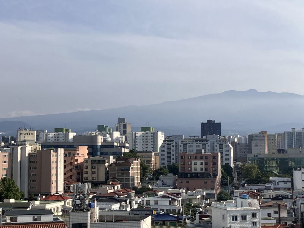
Because of the mountain, Jeju City in the north and Seogwipo City in the south can have completely different weather on the same day. The temperature difference can be several degrees—Seogwipo (south) is generally warmer year-round. It can be raining on one side while the other is completely dry. Prevailing winds hit Hallasan and split, creating different conditions on opposite coasts.
What this means practically: pack layers, check both Jeju City and Seogwipo forecasts separately, and be flexible. If you have a rental car and it’s raining where you are, it might be sunny 20 kilometers away.
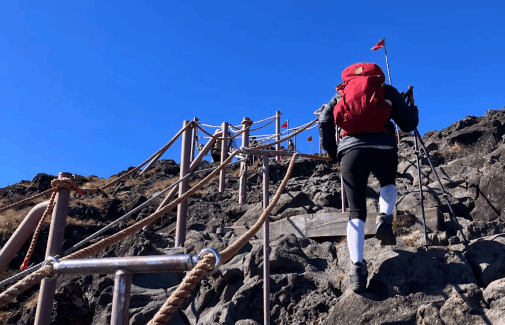
Hiking note: weather on Hallasan can be dramatically different from sea level. A warm sunny day at the base can become cold and windy at the summit. A ring of cloud often hangs around the peak—the summit may be completely fogged in. Bring thermal and wind layers regardless of the forecast. And expect strong wind at the top. I remember trying to call my wife from the summit and barely being able to talk.
A Few Other Things Worth Knowing
Waterfalls: Water drains through the volcanic rock quickly, which is why Jeju has virtually no major rivers. The waterfalls are small. If you are looking for something thunderous like Niagara or Iguazu, you’re going to be disappointed. That said, they have their own charm—I’d call them cute.
No rice fields: There is only one small rice paddy on Jeju, near Seogwipo City’s Hanon Oreum (하논 오름). The porous volcanic rock can’t hold water in paddies. Jeju developed around barley, sweet potatoes, and buckwheat instead. The barley fields in April and May are worth photographing.
Excellent spring water: The same porosity produces fantastic natural spring water filtered through volcanic rock. Korea’s most popular bottled water, Samdasoo (삼다수), comes from Jeju. The name means ‘Three Abundances Water’—referencing Jeju’s historical nickname, the island of three abundances: wind, stones, and women.
Lava tube caves: Hallasan’s eruptions created an extensive network of lava tubes. The Manjanggul Lava Tube (만장굴) is especially worth visiting.
Hiking Hallasan? You'll Need to Know This
All right, so you feel like you have the inside scoop on how Hallasan may affect your trip planning.
But what if you are planning to also hike Hallasan?
Fret not, I gotcha.
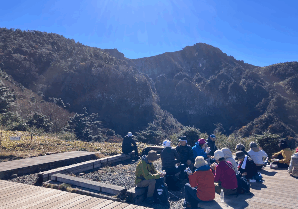
Climbing Hallasan was one of the top highlights of the many months I was in Jeju, bested only by the Jeju Olleh Trail. The views were breath-taking in more ways than one, and it was truly an experience that I will remember well into the future.
So much so that I plan to climb it again, this time with my kids.
Picking your Hallasan Trail
Hallasan offers four trails. Two go all the way to the summit. Two go only partway up and can be done in half a day. If you are not sure you want to commit to a full summit climb, the two partial trails are a completely legitimate option. They do not require advance registration and are suitable for families and occasional walkers.
Non-Summit Trails (No Registration Required)
Eorimok Trail (어리목): 4.7km one way, 2 to 2.5 hours round trip, easy-moderate. The trail has wooden decking throughout much of the route, making it accessible and easier on the knees. Does not reach the summit crater but gets you to Witsaeoreum, a smaller volcanic cone with views of the crater wall of Baengnokdam. In autumn, the dry riverbed section called Orimokkae Gok is lined with maple trees that turn red and yellow. Sora hiked this one with her mother, going up and back down the same way. Bus 240 from Jeju City stops here, once per hour.
Yeongsil Trail (영실): 3.7km one way, 1.5 to 2 hours round trip, easy but with steep and uneven stair sections. Often described as the most visually dramatic of the four trails. Passes through Yeongsilgiam, a formation of stone pillars associated in Jeju legend with the 500 sons of the island’s founding goddess Salmun Dehalma. Worth it for the scenery alone. Parking at the Yeongsil trailhead is limited—if the lot is full, you are looking at an additional 30-minute walk before you start. Get there early or take the bus. Bus 240 also serves Yeongsil, stopping there after Eorimok.
Both non-summit trails meet at Witsaeoreum, so you can go up one and come down the other.
Summit Trails (Registration Required)
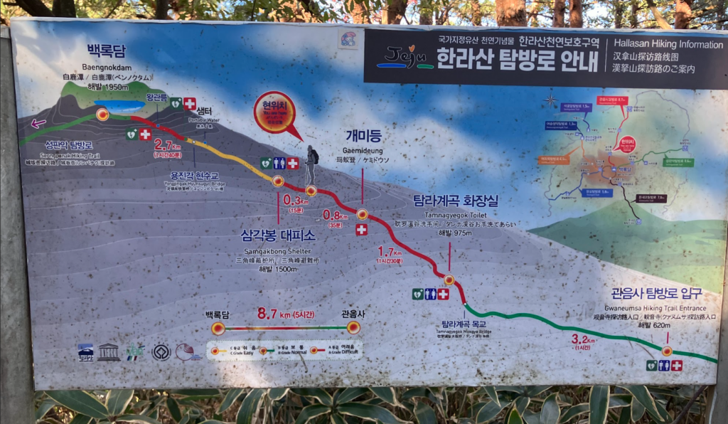
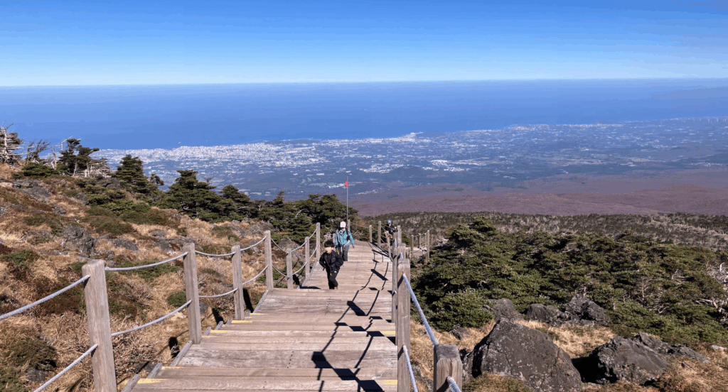
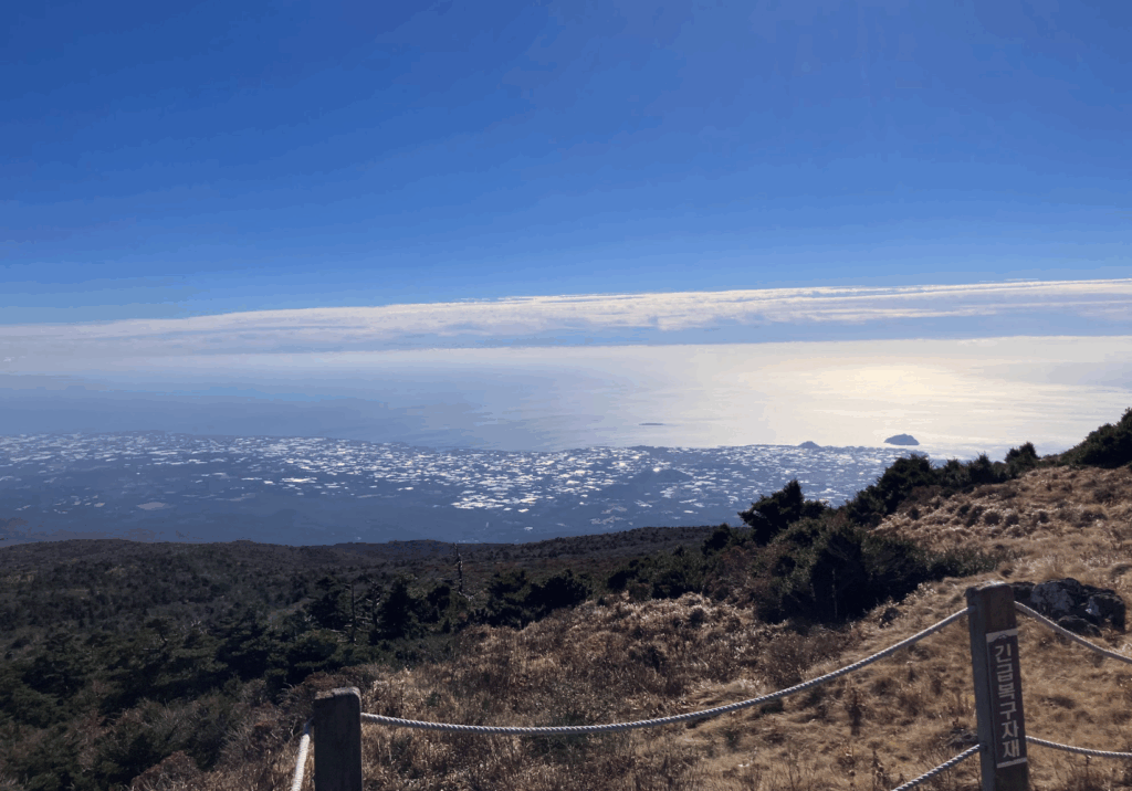
Seongpanak Trail (성판악): 9.6km one way, approximately 4.5 hours up and 3 hours down, moderate difficulty. A forest trail much of the way, which can get a bit monotonous. When you start the final push, the vegetation falls away and you see all the way to the eastern and southern coasts. Frequent bus service from both Jeju City and Seogwipo City.
Gwaneumsa Trail (관음사): 8.7km one way, approximately 5 hours up and 3.5 hours down, challenging. Steeper and rockier than Seongpanak, with a stretch of almost entirely jagged volcanic rock steps that are uneven and vary significantly in height. Going up is hard. Coming down is harder. The flipside: suspension bridges, a cave entrance, and views of the northern and eastern coast including Jeju City. One bus per hour—plan your return journey carefully.
Which Trail Should You Take?
I went up Seongpanak and came down Gwaneumsa. In hindsight, that was the wrong choice for me—partly because Gwaneumsa was fully booked for my preferred date, and partly because the Gwaneumsa descent on wet rocks with tired knees was genuinely punishing.
Sora’s recommendation, which I endorse: go up Gwaneumsa and come down Seongpanak. The harder climb going up is easier to manage than the harder descent coming down. Wet knees on jagged volcanic rock steps is not a fun way to spend an afternoon.
Booking Your Climb: This Part Matters
No Registration, No Climbing
You must register online before hiking either summit trail at visithalla.jeju.go.kr. Daily limits are strictly enforced: Seongpanak allows 1,000 hikers per day. Gwaneumsa allows 500.
Registrations open on the first day of the month for the following month. If you want to climb in February, you need to go online on January 1st. During popular seasons—which is essentially every season—slots fill fast. Sora compared it to booking concert tickets in Korea. Our advantage as visitors is flexibility: most mainland Koreans fly in for weekend climbs. Weekday slots are more available.
If you register for Seongpanak, you must start there but can choose which trail to descend. Same rule applies for Gwaneumsa. You’ll receive a QR code by email or text—screenshot it. Scan at the trailhead entrance and again at checkpoints. Rangers enforce cutoff times at checkpoints. Being five minutes late means being turned back. No exceptions.
Cutoff Times
These vary by season—check the current schedule before you go. At time of writing: the checkpoint cutoff is around 11:30 AM in winter and 12:00 to 12:30 PM in summer. The summit cutoff is around 1:00 to 1:30 PM depending on season. The trail opens as early as 5:00 AM. Starting at 7:00 AM is pushing it. Earlier is better. You must complete everything and be off the mountain the same day—no camping.
Which Season to Climb?
I climbed in November, on a day when the weather was clear and the air crisp but not hot. The summit was awfully windy—it’s Jeju, the land of stone, wind, and women—so that’s to be expected. The leaves had started showing their fall colors, and despite my very slow descent, I still marveled at the beauty around me.
Fall is a great time to climb. Spring is good too—you trade the fall colors for wildflowers.
Summer can be brutally hot and humid near the summit where there is no shade for a couple of hours. Bring considerably more water than you think you need.
Winter: Hallasan in the snow is supposed to be beautiful, and I believe it. But if you plan to climb in winter, you need proper winter climbing gear, including crampons. This is not optional.
Prepping For Your Climb
What to Bring
Water: Bring more than you think you need. The water from faucets at the rest area bathrooms is not reliably safe to drink. There are no convenience stores anywhere in the national park. Carry everything in with you.
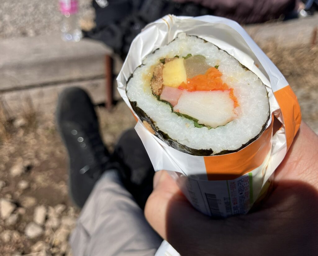
Food: Bring lunch and snacks. Nothing is available on the trails.
Hiking poles: Strongly recommended. They make the ascent easier and the descent significantly safer on the Gwaneumsa rocky sections.
Knee braces: If you have had any prior knee issues, bring them. I did not, and I paid for it coming down Gwaneumsa. I hobbled back to my hotel near Dongmun Market, went straight to a pharmacy (약국, yakguk), bought a knee brace, and wore it for the next two days. Learn from my mistake.
Footwear: Proper hiking boots. The trails are rocky and slippery after rain.
Layers: Summit weather can be 10 to 15°C colder than the base. Bring warm and wind layers even in summer.
Training: The ascent is manageable with some preparation. The descent is where people get caught out, particularly on Gwaneumsa. Eccentric training helps: slow weighted lunges and squats, lateral hops, wall sits. Going sideways in a zigzag manner on steep descents also takes pressure off the knees.
The Korean Ramyeon Ritual
One thing I did not expect: at the rest area checkpoints, a significant number of Korean hikers pull out a thermos of hot water and make instant ramyeon (라면). On South Korea’s tallest mountain. It is apparently a standard part of the hiking experience.
The technical issue—that water boils at a lower temperature at altitude, meaning the noodles never quite cook properly—is apparently beside the point. Sora confirmed that yes, undercooked ramyeon at a mountain checkpoint is a known and accepted part of the tradition.
BTW: Signs at checkpoints ask hikers to use only half the seasoning packet and half the water, and not to discard leftover broth. It became an environmental issue. If you do the ramyeon thing, dispose of everything properly.
One More Thing About the Social Experience
Koreans are not known for talking to strangers. On the subway, at a bus stop, in a restaurant—you generally keep to yourself. Hallasan is different.
Sora climbed the summit alone—specifically in November, the day after it had snowed, because she wanted to see the mountain in winter conditions and nobody else was available. Her observation: being alone on the trail made it easier to talk to other hikers. When everyone is doing something difficult together, something shifts. People share snacks. They check on each other at checkpoints. They shout 파이팅 (paiting) to strangers on steep sections.
It is one of the more unusual social experiences available on the island. Worth knowing about before you go.
Wrapping Up
Even if you never set foot on a trail, Hallasan will shape your visit.
Here’s the thing I wish someone had told me before my first trip to Jeju: You do not have to climb it, and most of you will not.
But you really should.
And if you do climb it?
You’ll understand the island in a way that’s hard to explain. Standing at the summit, looking out at the coastline, you realize that everything down there—every village, every oreum, every stone wall—came from right where you’re standing.
Start early. Bring layers. Don’t trust the weather forecast. And give the mountain the respect it deserves.
My knees still remind me of my descent down Gwaneumsa.
But I’d do it again. In fact, I will.
Essential Information
Registration: visithalla.jeju.go.kr (required for summit trails before hiking)
Reservations open: First day of each month for the following month
Daily climber limits: Seongpanak 1,000 / Gwaneumsa 500
Trail conditions and cutoff times: Check website before hiking—times vary by season
Non-summit trails: Eorimok and Yeongsil—no registration required, Bus 240 from Jeju City; bus drops you 30-45 minutes from trailheads.
Transportation: Seongpanak has frequent bus service; Gwaneumsa approximately once per hour
Best hiking season: September through November
Allow: 8 to 9 hours for summit hikes including rest time. Start as early as possible.
